- Start: Lory State Park, Fort Collins, CO.
- Distance: 25 Miles (5,500′) or 50 Miles (11,000′)
- Min/Max Elevation: 5,444′ / 7,087′
- Average Elevation: 6,200′
- Terrain: 85% singletrack, 15% dirt road
- Fauna: Abert squirrels, deer, black bears
- Registration Caps: 450 total (200 50mi / 250 25mi)
- Time Allowance: 50 mile – 14 hours; 25 mile – 12.5 hours
- Date: May 2027
- Start Time: 50 mile: 5:30am; 25 mile: 7:00am
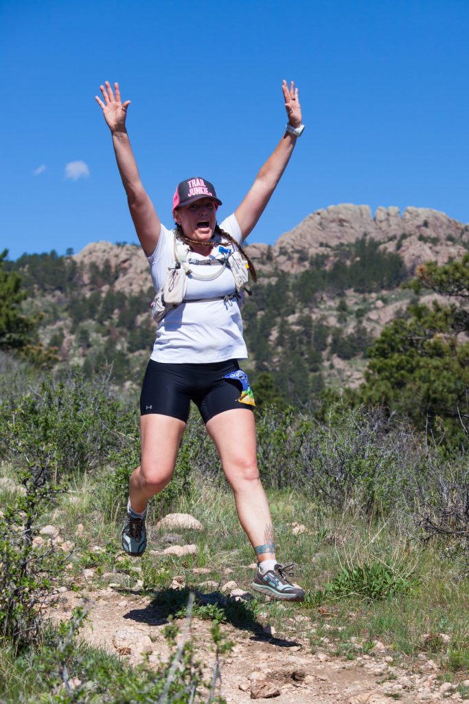
Welcome to the Quad Rock 50 and 25 mile trail races, an event put on by trail runners for trail runners.
Taking place on the trails and hills west of Fort Collins in Lory State Park and Horsetooth Mountain Park, the Quad Rock 25/50 will take you on a tour of the Fort Collins skyline, situated on the northeastern stretches of Colorado’s mighty Rocky Mountains. Look east from the course’s high ridges and you’ll see the Great Plains extending into Nebraska as far as the eye can see. Look west and you’ll take in summit views, dominated 30 miles away by a towering Longs Peak.
We aspire to not only offer a first class trail racing experience on a challenging, scenic and impeccably marked course, but also a top-notch post-race experience that will leave your bellies full and the stories flowing.

Registration
Registration for 2027 will open December 15, 2026.
50 Mile Race Fees:
Dec 15 – Dec 31: $155 + $10.30 fee
Jan 1 – March 31: $170 + $11.20 fee
April 1 – May 4: $180 + $11.80 fee
25 Mile Race Fees:
Dec 15 – Dec 31: $125 + $8.50 fee
Jan 1 – March 31: $140 + $9.40 fee
April 1 – May 4: $150 + $10.00 fee
What You Get in Return for Your Registration Fee
- A beautiful, well-marked and challenging course
- Enthusiastic, knowledgeable race and aid station staff & volunteers
- Fully stocked aid stations
- Choice of fitted or straight-cut race T-shirt
- Finisher award
- Free race photos
- Finish line meal and awards
- Vegetarian, vegan, gluten free and non-alcoholic options are available as part of our standard race fare
- Professional medical & emergency communications coverage
- Real-time results processing with splits from all aid stations
- Weekly on-course training runs organized by members of the Gnar Team
- Rocked quads.
Wait Lists
Quad Rock typically turns over 75-80 runners total between the two distances on our wait lists. If you are selected from the waitlist, you are given the opportunity to accept/decline the invitation. Your credit card will not be charged until you accept. Your fellow runners in line appreciate your prompt response.
Transfer Credit & Distance Change Policy
If you are not able to race, we will be able to offer a race transfer credit that can be applied to any future Gnar Runners race (valid for 12 months). Credit deadlines are as follows:
Until Jan 31: 100% credit of registration (excluding RunSignup fees)
Feb 1 – March 31: 75% credit of registration (excluding RunSignup fees)
April 1 – May 4: 50% credit of registration (excluding RunSignup fees)
**In order to receive your credit, you must cancel your registration through the RunSignup registration platform.
Deferrals:
- Log in to your RunSignup account
- Go to Profile -> Upcoming Races -> Quad Rock -> Manage Registration
- At the bottom of the page, select “Defer Registration” and follow the automated process.
- While RunSignup will prompt you to, you DO NOT have to immediately choose which race to apply your credit to. Once you hit “Confirm Deferral” and see the “Your registration has been deferred” message, your credit is in the system and will be valid for one year past the event date.
Distance Switch:
- Log on to your RunSignup account
- Go to Profile -> Upcoming Races -> Quad Rock -> Manage Registration
- At the top, click the link to “Transfer Event”
- Follow the steps to register for the race in the new distance
Runners in the 25 mile race can pay the additional registration fee to upgrade to the 50 mile race. There is no charge for 50 mile runners dropping down to the 25 mile race.
The online deadline to transfer is Thursday (5/8) at midnight. It can also be done in person at packet pickup on Friday (see below).
50 milers who drop to the 25 mile race by packet pickup on Friday will be officially entered into the 25 mile race starting at 7am and will be eligible for 25 mile awards. Otherwise all 50 mile entrants will be expected to start with the 50 mile race at 5:30am.
Cancellation Policy
Entries are non-refundable. Entries are non-transferable, except for transfers via the wait list. In the event the race is cancelled due to extreme weather, fire, disease or for some other unforeseeable event, we cannot offer refunds or credits.
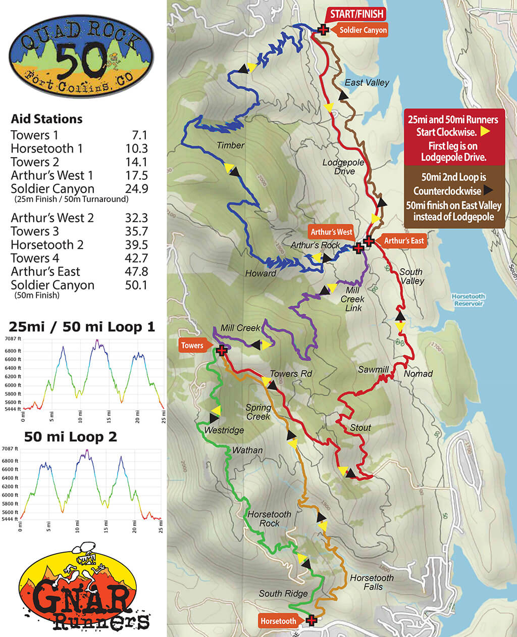
Course & Aid Stations
The 50 mile course will have approximately 11,000ft of vertical gain.
The 25 mile course will have approximately 5,500ft of vertical gain.
The first 25 mile loop for both distances will run clockwise from Soldier Canyon. 50 mile runners will run a second loop in the opposite direction.
Course Map
Park Trail Maps
Interactive Map
Course GPX File
- Quad Rock 50mi (Current for 2026)
- Quad Rock 25mi (Current for 2026)
Aid Stations
| Aid Station | Mile Split | Total | Gain | Descent | Cut-Off | Drop Bag |
|---|---|---|---|---|---|---|
| Towers Road | 7.1 | 7.1 | 1728 | 285 | – | No |
| Horsetooth Trailhead | 3.2 | 10.3 | 420 | 1540 | – | Yes |
| Towers Road | 3.8 | 14.1 | 1641 | 484 | – | No |
| Arthur’s Trailhead | 3.4 | 17.5 | 323 | 1644 | 2:30p | No |
| Timber *Unmanned – WATER ONLY* | 4.3 | 21.8 | 1354 | 230 | – | No |
| Soldier Canyon | 3.1 | 24.9 | 90 | 1287 | 12:15p | Yes |
| Timber *Unmanned – WATER ONLY* | 3.1 | 28.0 | 1287 | 90 | – | No |
| Arthur’s Trailhead | 4.3 | 32.3 | 230 | 1354 | 2:30p | No |
| Towers Road | 3.4 | 35.7 | 1644 | 323 | – | No |
| Horsetooth Trailhead | 3.8 | 39.5 | 484 | 1641 | 4:35p | Yes |
| Towers Road | 3.2 | 42.7 | 1540 | 420 | – | No |
| Arthur’s East | 5.1 | 47.8 | 44 | 1034 | – | No |
| Soldier Canyon Finish | 2.3 | 50.1 | 115 | 268 | 7:30p | Yes |
We will make every effort to place the Timber Unmanned aid station, but muddy road conditions may prevent this from happening. We will announce if it may not be placed in the pre-race email; hopefully any muddy day is also a cool/wet day.
With the exception of the Timber Unmanned (water only) and Arthur’s East (limited aid), all aid stations will be fully stocked and staffed with volunteers.
All full service aid stations will stock the following items:
- Gnarly Fuel2O Nutrition sports drink.
- Naak gels, purees, energy bars and waffles
- Water and ice (ice may be limited at the Towers aid station)
- Salty snacks: Pretzels, Potato Chips, Corn Chips, Saltines
- Fruit: Oranges, Bananas, Watermelon
- Sweets: Cookies, M&M’s, Gummy bears, Mini Candy Bars, Fig Newtons
- Soda: Coke, Ginger Ale
- Hot Drinks: Coffee, Tea, Cocoa
- PB&J/Nutella, Turkey & Cheese Sandwiches, Quesadillas, Grilled Cheese, Ramen, Boiled Potatoes
- POPSICLES
***There will be GF/Vegan alternatives for nearly all non-GF/V standard offerings. These are typically held back to save them for those who need them, so please ASK! Also note that while we will do our best to keep utensils and trays separated for these as well as common allergens, this is the backcountry and cross-contamination can occur.
While we will provide plenty of electrolyte options in drink mix and salty real foods, we deem the risks associated with salt in concentrated pill form to be more than we’re comfortable providing. We won’t restrict runners from using their own salt caps, but will not have them available at aid stations.

Time Cut-Offs
Course cut-offs will be enforced at the following aid stations:
- Soldier Canyon (Mile 24.9) at 12:15pm. 6:45 Total time. **50 Mile Only**
- Arthur’s Trailhead at 2:30pm. 9:00 Total time / 32.3 Miles (50 Mile) / 7:30 Total time / 17.5 Miles (25 Mile). This cut-off is enforced in both directions – no traffic continues from Arthur’s in either direction in either distance from Arthur’s after 2:30p.
- Horsetooth Trailhead (Mile 39.5) at 4:35pm. 11:05 Total time **50 Mile Only**
This is a challenging course so some runners may find it difficult to meet these cut-off times. Any 50 mile runner who drops out or fails to meet the course cut-offs after completing the first 25 mile loop will be given a finish time in the 25 mile race, but will not be eligible for 25 mile overall or age group awards.
Drop Bags
If you have any specific personal needs, drop bags will be allowed at the Horsetooth Trailhead (Mile 10.3 and 39.5) and Soldier Canyon (Mile 24.9 for the 50 milers).
Horsetooth Drop Bags must be dropped off at the start by 5:25am on race morning. We will not have a second transport shuttle for the later 25mi start.
Soldier Canyon (Finish/25 mile turn) drop bags may be dropped off any time before the start of each race.
Please provide your own bag and keep it to a reasonable size (small duffel bag or stuff sack). Clearly label it with your name and bib number. Please do not leave any valuable items in your drop bags – volunteers are not responsible for lost items.
Horsetooth drop bags will not be returned to the start until that aid station shuts down and packs up at the end of the day (after 5p). If you finish early and need your drop bag before heading home, you are welcome to drive around to the Horsetooth trailhead (about 30 minutes from the start/finish) to pick up your drop bag. Unclaimed bags will be left in a lost and found box at Altitude Running for two weeks before being donated.
Course Marking
The course will be well marked with pink flagging and pink pin flags. Important intersections will be supplemented with flour ground markings and directional arrows. On longer stretches of trail without intersections, confidence flagging will be placed approximately every quarter mile. Turns will be marked heavily.
Toilets
Permanent park restrooms are available at the Soldier Canyon, Arthur’s, and Horsetooth trailheads. Additional portable toilets will be available for race participants at the Soldier Canyon start/finish. Towers will have a backcountry setup (but you’re better off waiting for any other option).
Training
There are organized training runs most Saturdays January-May for Quad Rock, with a special Course Preview Run and Cookout on April 11, 2026. See the Fort Collins Trail Runners Facebook Group for details on times, locations & routes. See our Community Page for more info on both.
Crew Access
Family and friends can meet their runners at the start/finish at Soldier Canyon, Arthur’s Trailhead, and the Horsetooth Trailhead. We are asking any runners who are able to arrive in a vehicle that already has a state park pass to do so. We WILL provide passes for any that do not. Due to some recent charges, we now have to pay per pass, and appreciate your help keeping costs down. As always, any additional crew or family vehicles will need to pay the regular $10 park entrance fee. The Horsetooth Trailhead is separate from Lory State Park and requires its own $10 day fee for Larimer County Parks. Carpooling is highly recommended to save on park fees and limit traffic and parking congestion at the trailheads – especially the Horsetooth trailhead, which is likely to be packed with regular park visitors.
All trails are open to the public, so family and friends are allowed to run, hike, or bike on the course; however, pacing or crewing outside designated aid stations is not allowed and will result in the disqualification of your runner.
The Arthur’s Rock Trailhead is easily accessed from the start/finish area by driving 2 miles south on the main Lory State Park access road.
The Horsetooth Mountain Park – Upper Trailhead is located approximately 13 miles – or 30 minutes – from Lory State Park. It can be accessed by taking Lodgepole Dr out of Lory State Park to County Road 23/Centennial, and then heading south (right) along the east side of Horsetooth Reservoir. After 4.5 miles on Centennial, make a right up the hill to stay on CR 23 for another 1.5 miles. Make a right on County Road 38E and follow the road around the south side of the Reservoir for 4.5 miles. The Horsetooth Mountain Park trailhead is about a mile past the Horsetooth Tavern, at the crest of the hill, on the right.
NO Crewing is allowed at the Towers Aid Station.
Detailed Course Directions
Start to Arthur’s Trailhead:
The race will start in the parking lot of the Soldier Canyon Picnic Area. Runners will follow the road out of the trailhead and head south on the Lodgepole Drive loop (where runner vehicles are parked) and will continue two miles down the main park road to the Arthur’s trailhead.
Arthur’s Trailhead to Towers Aid Station:
Take the first left into the Arthur’s horse trailer parking lot to access the east side of the South Valley loop trail and run another mile. Immediately after crossing the Horsetooth Mountain Park border, turn right onto the Sawmill connector trail and continue up Sawmill to the Stout Trail. Take a left on Stout to connect over to Towers Rd, where the course takes a right up the hill to the Towers Aid Station at the intersection of Towers Rd and the Mill Creek / Spring Creek trails.
Towers Aid Station to Horsetooth Trailhead:
From the Towers aid station, turn left onto the Spring Creek Trail. Take the Spring Creek Trail all the way down to a three-way intersection after about 1.7 miles, turning left at the intersection to stay on the Spring Creek Trail. Stay straight to connect with the Horsetooth Falls Trail after half a mile and follow it another mile to the Horsetooth Mountain Park Trailhead and race aid station.
Horsetooth Trailhead to Towers Aid Station:
From the Horsetooth Trailhead, take the Soderberg service road up to the Horsetooth Rock Trail, and turn left, continuing on the hiking trail up to the Wathan/Westridge Trail junction. Turn right off the Horsetooth Rock Trail onto the Wathan/Westridge Trail and continue straight (stay left) on Westridge at the intersection of Wathan/Westridge shortly after you turn off the Horsetooth Rock Trail. Follow it north to Towers Rd. Take a right on Towers Rd and the aid station will be right around the corner.
Towers Aid Station to Arthur’s Trailhead:
From the Towers Aid Station, take a left on the Mill Creek Trail and follow it all the way back to the Arthur’s Trailhead in Lory State Park. Midway down Mill Creek, take a left at the Loggers T-junction. Shortly after you enter Lory State Park, the Mill Creek Trail will come to another T-junction. Take the right onto the Mill Creek Link Trail and follow that to the South Valley Trail, where you’ll make a quick left to Arthur’s Trailhead.
Arthur’s Trailhead to Soldier Canyon Start/Finish Area:
Start up the Arthur’s Rock Trail and about 3/4mi up, take a sharp left to connect to the Howard Trail. Take a right on Howard and follow it towards Arthur’s Rock. At the T-junction with the Timber Trail under Arthurs Rock, take a left. The first part of the Timber Trail is a 4WD road. About 3/4mi down the road, take the 90 deg right turn onto the single track Timber Trail. Follow Timber all the way to the trailhead. Exit the Timber trailhead and take the short connector trail back to the Soldier Canyon start/finish.
50 Mile Finish:
50 Milers will run the same 25 mile loop in reverse, with one exception in the final 2 miles. From the last stop at Arthur’s Trailhead, runners will stay on the East Valley Trail (not the park road) all the way to the finish at Soldier Canyon.
Race Rules
Race rules are designed to provide a safe and fair experience for everyone involved and to help ensure our ability to produce the race again next year. Major rule infractions by racers will result in immediate disqualification of the racer. Please do not argue with or harass our volunteers. Please direct any questions and feedback to the Race Directors on race day or contact us ahead of race day here.
- The 50 mile race will be limited to 14 hours and will end at 7:30pm. Please refer to the Aid Station section of this page for intermediate cut-offs.
- At each aid station (except the first time through Towers mile 7.1), volunteers will record runner bib numbers. Runners are responsible for making sure that aid station volunteers record their number. Please make sure that your bib number is visible from the front and call out and confirm your number when passing through an aid station. This is important so that we can keep track of runners and know that you are not lost or injured.
- If you need to drop out of the race for any reason, you must check out with the nearest aid station or course volunteer.
- Purposeful littering is prohibited and will result in an immediate disqualification.
- Stay on the trail. No bushwhacking or short cutting. In case of wet trail conditions, please run through any muddy sections to avoid widening the trail. Yield to pedestrian and horses. Mountain bikers should yield to runners, but please use common sense in all circumstances.
- Pacers are not allowed. Crewing is allowed at designated aid stations only.
- No mechanical aid (poles, traction devices, etc.) unless approved by race staff prior to the race for a specific reason.
- Dogs are not allowed on the course with runners.
Schedule
Friday 5/8:
| 4:00-7:00p: | Optional packet pick-up at Altitude Running 2531 South Shields St #2N, Fort Collins, Colorado 80526 (Northwest corner of Drake & Shields) |
Saturday 5/9:
| 4:00a: | Lory State Park Open to Runners (See parking section for details) |
| 4:00-5:15a: | 50 Mile Check-In & Packet Pickup (Give yourself 15-20 minutes to park and get to check-in) |
| 5:25a: | 50 Mile Pre-Race Briefing |
| 5:30a: | 50 Mile Race Start |
| 5:45-6:45a: | 25 Mile Check-In & Packet Pickup (Give yourself 15-20 minutes to park and get to check-in) |
| 6:55a: | 25 Mile Pre-Race Briefing |
| 7:00a: | 25 Mile Race Start |
| 10:15a: | Lead 25 Mile Runners Finish |
| 11:00a: | Post-Race Meal Opens |
| 11:45a: | 25 Mile Overall Awards, followed by age group awards on a rolling basis |
| 12:15p: | Soldier Canyon Cut-Off for 50 Mile Race (Mile 24.9) |
| 12:45-1:30p: | Lead 50 Mile Runners Finish |
| 1:30p: | 25 Mile Age Group Awards |
| 2:30p: | Arthur’s Aid Cut-Off (Mile 32.3 / 17.5) |
| 2:30p: | 50 Mile Awards Begin. Offered on a rolling basis as award categories fill out. |
| 4:35p: | Horsetooth Aid Cut-Off (Mile 39.5) |
| 7:30p: | Race Finish |
| 8:30p: | Event Area Closed |
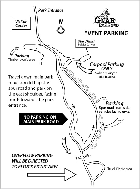
Parking & Directions
Parking for 50 mile runners will be available at Lory State Park beginning at 4:00am and for 25 mile runners beginning at 5:45am. We are asking any runners who are able to arrive in a vehicle that already has a state park pass to do so. We WILL provide passes for any that do not. Due to some recent charges, we now have to pay per pass, and appreciate your help keeping costs down. As always, any other vehicles (crews/spectators) will be required to have a Colorado State Parks Annual Pass or purchase a park entry pass on-site for $10.
Parking spaces in the Soldier Canyon start/finish area will be given to carpools of 2 or more registered runners on a first-come, first-serve basis.
All other vehicles will be directed to park in the Timber trailhead lot and on the east side of the Lodgepole Drive spur road. Lodgepole Drive will be restricted to one-way traffic from south to north. Vehicles will enter on the south end of Lodgepole Drive and will fill in the first available space on the right side of the road. Vehicles will exit on the north end of Lodgepole Drive.
**Please give yourself an extra 15-20 minutes to park and get to race check-in on time. Late arrivals may have up to 1 mile or longer to walk to the start.**
Driving Directions
708 Lodgepole Dr, Bellvue, Colorado 80512
You’ve Got This!!