- Start: Ben Delatour Scout Ranch, Red Feather Lakes, Colorado
- Distances: 50 Mile (8,500′ gain), 50K (4,200′ gain), Half Marathon (1,700′ gain)
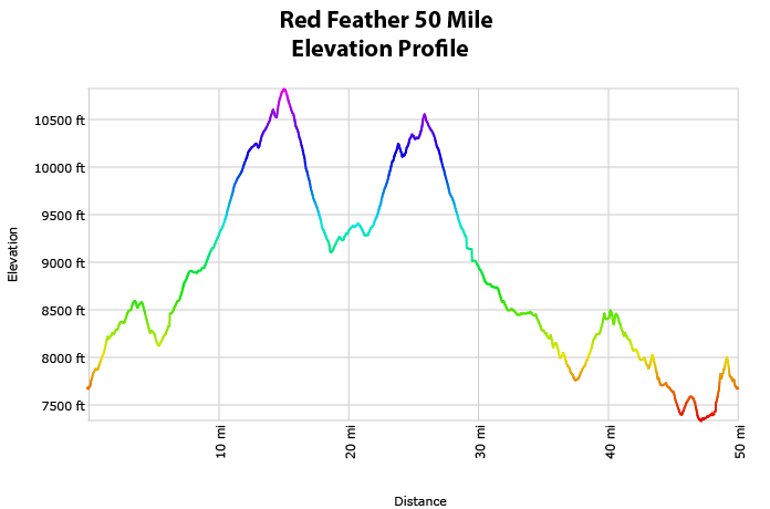
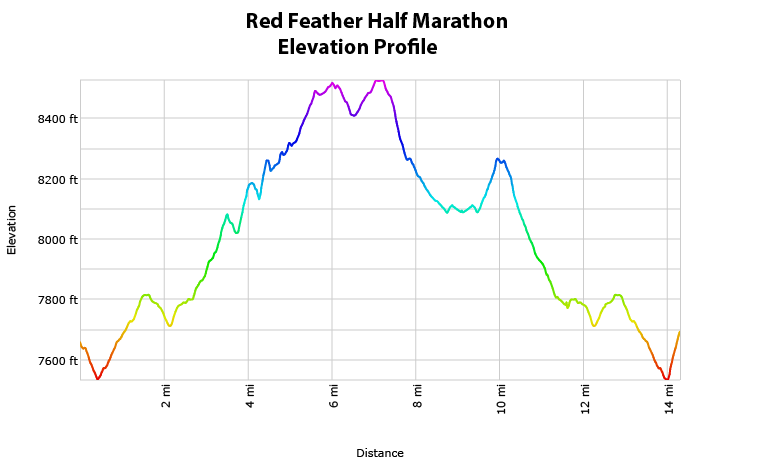
- Min/Max Elevations: 7,350′ / 8,500′ (50K/Half), 7,350′ / 10,828′ (50mi)
- Average Elevations: 8,700′ (50mi), 7,800′ (50K/Half)
- Terrain: 70-80% singletrack, 20-30% dirt road
- Fauna: Moose, raptors, elk, mule deer, black bears, mountain lions
- Registration Caps: 500 total
- Time Allowance: 16 Hours (50Mi), 11 Hours (50K), 6 Hours (Half)
- Dates: September 20-22, 2024
- Start Times: 6:00a (50mi), 7:00a (50K), 8:30a (Half Marathon)
- Kids Race:: FREE, 1mi, Sunday @ 11:30a
Welcome to the Red Feather Trail Jamboree, a three-day trail running weekend put on by trail runners for trail runners.
Come enjoy the clean air and wild spaces of the Red Feather Lakes region in Northern Colorado! Take advantage of the opportunity to explore some new trails on the private land of the Ben Delatour Scout Camp and surrounding national forest.
The half marathon courses is mostly smooth dirt with moderate climbs and no on-course cut-offs. The 50km course takes in some more technical terrain over its first 10 miles before connecting with the flowing and runnable trails within the National Forest Service system. Like the half marathon, there is no time cut-off. The 50 mile route combines 5 different trail systems within the National Forest and Boy Scout property with a high point just under Middle Bald Mountain in the Laramie Mountains. There is a single cut-off at the 50K point.
With miles through moose-heavy forest and fields, streams and rocks, this route has something for everyone. Facilities at the race venue include campgrounds and cabins for rent, a community dinner in the dining hall and an on-site shower house. We want to make this a fun, family-friendly weekend for all!
We aspire to not only offer a first class trail racing experience on a scenic and impeccably marked course, but also a top-notch event experience that will leave your bellies full and the stories flowing.
Registration
50K Race Fees:
Jan 15 – April 30: $105
May 1 – July 31: $120
Aug 1 – Sept 20: $130
Packet Pickup: $150
50 Mile Race Fees:
Jan 15 – April 30: $115
May 1 – July 31: $130
Aug 1 – Sept 20: $140
Packet Pickup: $160
Half Marathon Race Fees:
Jan 15 – April 30: $90
May 1 – July 31: $100
Aug 1 – Sept 20: $110
Packet Pickup: $120
3-Day Challenge Race Fees:
Jan 15 – April 30: $240
May 1 – July 31: $260
Aug 1 – Sept 20: $300
Packet Pickup: $325
What You Get in Return for Your Registration Fee:
- Beautiful, well-marked and challenging courses
- Enthusiastic, knowledgeable race and race staff & volunteers
- Gender specific race T-shirt
- Finisher award
- Free race photos
- Post-race BBQ
- Vegetarian, vegan, gluten free and non-alcoholic options are available as part of our standard race fare
- Medical & emergency communications coverage
Waiting List
If the race fills, a waitlist will be established. If you are selected from the waitlist, you are given the opportunity to accept/decline the invitation. Your credit card will not be charged until you accept. Your fellow runners in line appreciate your prompt response.
Transfer Credit & Distance Change Policy
If you are not able to race, we will be able to offer a race transfer credit that can be applied to any future Gnar Runners race (valid for 12 months). Credit deadlines are as follows:
Until April 30: 100% credit of registration (excluding UltraSignup fees).
May 1 – July 31: 75% credit of registration (excluding UltraSignup fees).
August 1 – September 15: 50% credit of registration (excluding UltraSignup fees).
** In order to receive your credit, you must cancel your registration through the UltraSignup registration platform. You can cancel your registration by clicking the link at the bottom of your registration receipt or by logging into your UltraSignup account
The credit will be valid for one year from the event date, and will be tied to your account. It will apply automatically the next time you register for a Gnar Runners event.
Registered runners may also switch between race distances. Runners stepping up in distance can pay the additional registration fee to upgrade; there is no charge for dropping down in distance. This process is self managed through your registration receipt and/or Ultrasignup account. The transfer deadline is Wednesday (9/20) at midnight.
Cancellation Policy
With the exception of waitlist transfers, entries are non-refundable and non-transferable. In the event the race is cancelled due to extreme weather, fire, disease or for some other unforeseeable event, we cannot offer refunds or credits.
Course & Aid Stations
The 50K course will have approximately 4,200ft of vertical gain.
The 50 Mile course will have approximately 8,500ft of vertical gain.
The Half Marathon course will have approximately 1,700ft of vertical gain.
Course Maps
Interactive Map
Course GPX File
- Red Feather Trail Jamboree 50K GPX (Current for 2024)
- Red Feather Trail Jamboree 50 Mile GPX (Current for 2024)
- Red Feather Trail Jamboree Half Marathon GPX (Current for 2024)
Red Feather Trail Jamboree Camping Map
Facility Map of the Ben Delatour Scout Camp
Trail Map of the Ben Delatour Scout Camp
Course Profiles
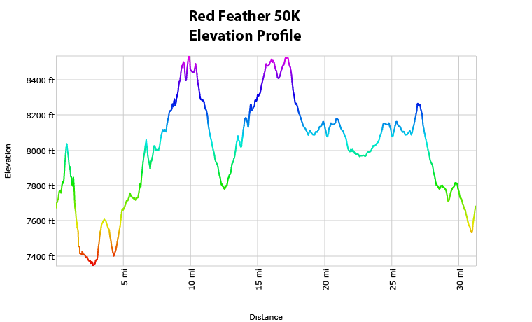 |
 |
 |
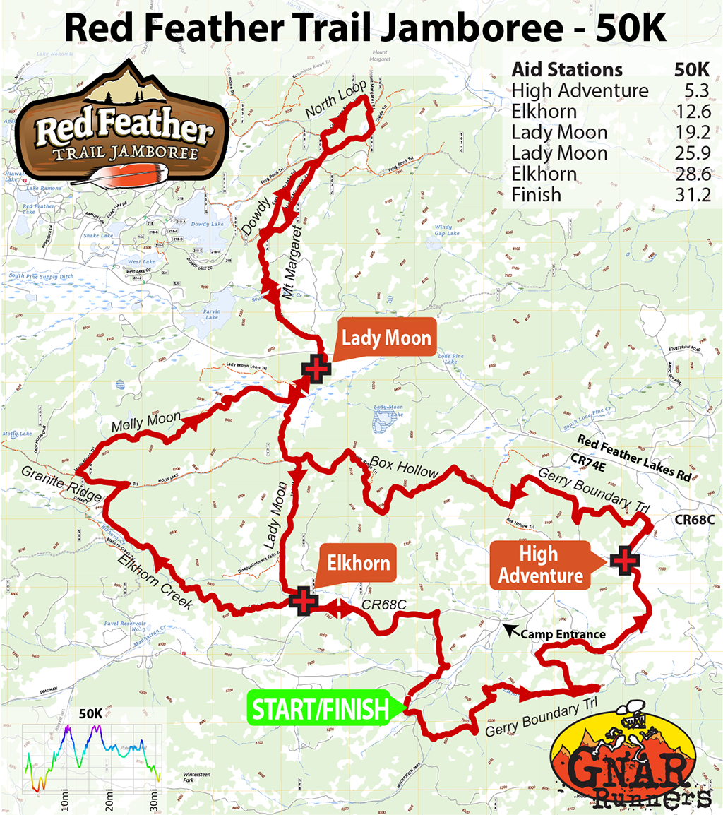
Aid Stations – 50K
| Aid Station | Mile Split | Total | Gain | Descent | Cut-Off |
|---|---|---|---|---|---|
| High Adventure | 5.3 | 5.3 | 1190 | 1150 | – |
| Elkhorn | 7.3 | 12.6 | 810 | 880 | – |
| Lady Moon | 6.6 | 19.2 | 960 | 790 | – |
| Lady Moon | 6.7 | 25.9 | 640 | 640 | – |
| Elkhorn | 2.7 | 28.6 | 500 | 270 | – |
| Finish | 2.6 | 31.2 | 160 | 470 | 6:00p |
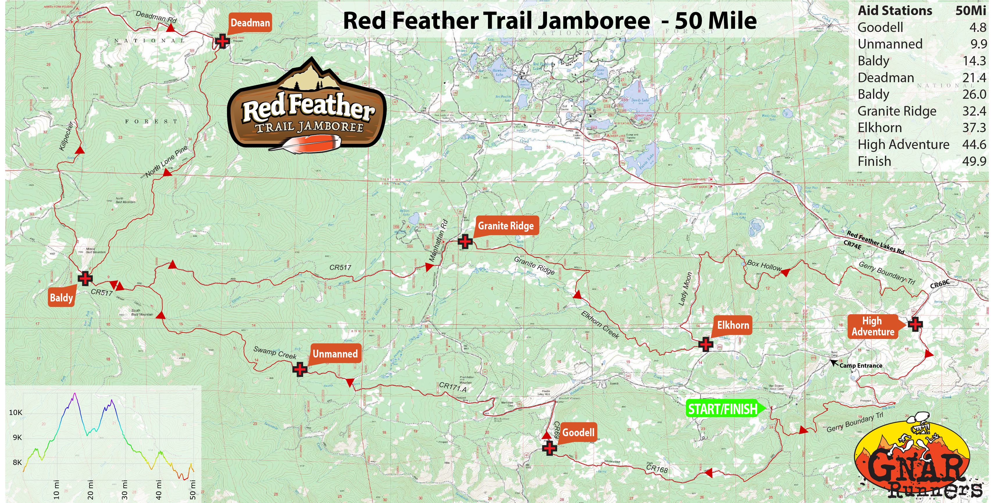
Aid Stations – 50 Mile
| Aid Station | Mile Split | Total | Gain | Descent | Cut-Off |
|---|---|---|---|---|---|
| Goodell | 4.8 | 4.8 | 720 | 800 | – |
| Unmanned (Water Only) | 5.1 | 9.9 | 1400 | 350 | – |
| Baldy | 4.4 | 14.3 | 1400 | 100 | – |
| Deadman | 7.1 | 21.6 | 600 | 1900 | – |
| Baldy | 4.6 | 26.0 | 1500 | 300 | – |
| Granite Ridge | 6.4 | 32.4 | 400 | 1800 | 4:30p |
| Elkhorn | 4.9 | 37.3 | 350 | 800 | – |
| High Adventure | 7.3 | 44.6 | 880 | 810 | – |
| Finish | 5.3 | 49.9 | 1150 | 1190 | 10:00p |
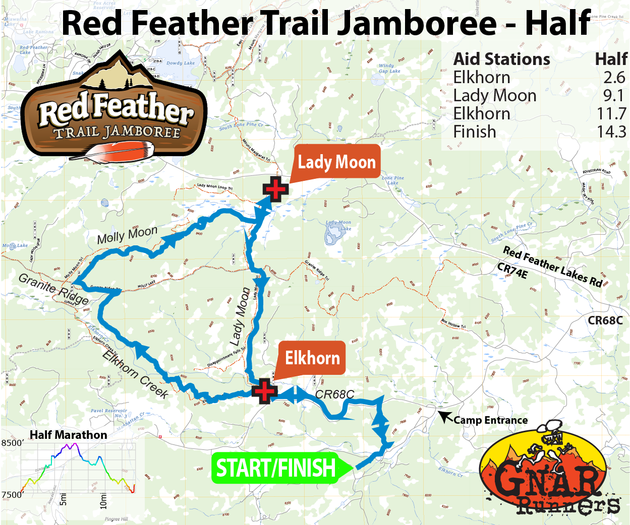
Aid Stations – Half Marathon
| Aid Station | Mile Split | Total | Gain | Descent | Cut-Off |
|---|---|---|---|---|---|
| Elkhorn | 2.6 | 2.6 | 260 | 90 | – |
| Lady Moon | 6.5 | 9.1 | 960 | 790 | – |
| Elkhorn | 2.6 | 11.7 | 390 | 190 | – |
| Finish | 2.6 | 14.3 | 90 | 280 | 2:30p |
All full service aid stations will stock the following items:
- Gnarly Nutrition sports drink.
- Water and ice
- Salty snacks: Pretzels, potato chips, corn chips
- Fruit: Oranges and Bananas plus additional variety depending on what might be available
- Sweets: Cookies, M&M’s, Gummy bears
- Soda: Coke, Ginger Ale
Time Cut-Offs
The 50K and Half Marathon distances have no intermediate cut-off times. Anyone who completes the full course is recognized as a finisher. Recommended pace to finish:
- 50K: 21:20 min/mi
- Half: 22:50 min/mi
The 50 Mile distance has one cut-off, which is in place to help ensure all runners are back to camp before darkness falls, while still allowing all to achieve at least a 50K distance for the day:
- Granite Ridge Aid Station (Mile 32.4) at 4:30pm. 10:30 Total time (19:27min/mi).
Drop Bags
If you have any specific personal needs, drop bags will be allowed during the 50mi race at the Deadman (mile 18.9) and Granite Ridge (mile 32.4) aid stations. No drop bags for the 50K or Half Marathon.
Drop Bags can be dropped off either at Thursday night’s packet pickup or on Friday morning any time up until the race start.
Please keep your drop bag to a reasonable size (small duffel bag or stuff sack). They should be clearly labeled with your name and bib number. Please do not leave any valuable items in your drop bags – volunteers are not responsible for lost items.
Drop bags will not be returned to the start until each aid station shuts down and packs up at the end of the day (likely Noon or after for Deadman, 5p or after for Granite Ridge). If you finish early and need your drop bags before heading home, you are welcome to drive around to the aid stations to pick up your drop bag. Unclaimed bags will be transported to Altitude Running post-race, available in the race’s lost & found box for two weeks before being donated.
Course Marking
The course will be well marked with pink flagging and pink pin flags. Important intersections will be supplemented with flour ground markings and directional arrows. On longer stretches of trail without intersections, confidence flagging will be placed approximately every quarter mile. Turns will be marked heavily.
Toilets
Restrooms are available at the Start/Finish as well as various locations around camp, the Elkhorn Trailhead/Aid, the Lady Moon Trailhead/Aid and the Granite Ridge Trailhead/Aid.
Crew Access
Family and friends can meet their runners at the Elkhorn, Lady Moon, Granite Ridge & North Lone Pine (Deadman) Trailheads. Carpooling is highly recommended to limit traffic and parking congestion at the trailheads.
All trails are open to the public, so family and friends are allowed to run, hike, or bike on the course; however, pacing or crewing outside designated aid stations is not allowed and will result in the disqualification of your runner.
Driving Directions:
Elkhorn Trailhead: From the Coral Rock Dining Hall Start/Finish, follow the main park road 1.2mi back out the main gate to CR68C (Boy Scout Road). Turn left (west) and go 2.0mi to the sign for the Elkhorn Trailhead. Turn right and follow the access road 0.2mi to the trailhead.
Lady Moon Trailhead: From the Coral Rock Dining Hall Start/Finish, follow the main park road 1.2mi back out the main gate to CR68C (Boy Scout Road). Turn right (east) and go 2.3mi to CR74E (Red Feather Lakes Rd). Turn left (west) and go 4.0mi to the sign for the Lady Moon Trailhead. Turn left into the parking lot.
Granite Ridge Trailhead: From the Coral Rock Dining Hall Start/Finish, follow the main park road 1.2mi back out the main gate to CR68C (Boy Scout Road). Turn left (west) and go 4.5mi to the 3-way junction with CR69 (Manhattan Rd). Turn right (north) and go 4.6mi to the sign for the Granite Ridge Trailhead. Turn right and follow the access road 0.2mi to the trailhead.
North Lone Pine Trailhead (Deadman): From the Coral Rock Dining Hall Start/Finish, follow the main park road 1.2mi back out the main gate to CR68C (Boy Scout Road). Turn left (west) and go 4.5mi to the 3-way junction with CR69 (Manhattan Rd). Turn right (north) and go 6.7mi to CR74E (Red Feather Lakes Rd). Turn left (west) and go 0.2mi to the 3-way intersection, and take another left onto CR86 (Deadman Rd). Go 4.2mi to the sign for the North Lone Pine Trailhead, and take a left into the lot.
Training
There will likely be organized training runs in August/September for Red Feather, including a course preview & trail work weekend centered on Friday/Saturday, August 16-17. See the Fort Collins Trail Runners Facebook Group for group run postings, as well as our Events Section of our Facebook page for more info.
Detailed Course Directions – 50K
Start to High Adventure Aid Station (Mile 5.3):
From the Coral Rock Dining Hall, head south on the main park road to the T-junction with the Gregg Boundary / Zimmerman Trails. Turn Left (east) and follow the internal camp trails for roughly 4.5mi through varied terrain, heading generally (but not exclusively) east and north to the road crossing of Larimer County Road 68C. The High Adventure aid station is located on the south side of the road, immediately across from the camp High Adventure Base.
High Adventure (Mile 5.6) to Elkhorn Aid Station – 1st Visit (Mile 11.2):
Cross the road and continue following the Gregg Boundary Trail for about 3.5mi through the High Adventure Base north/west to its junction with the Box Hollow Trail. Continue west on the Box Hollow Trail for roughly 2mi to its junction with the Lady Moon Trail. Turn left onto the Lady Moon Trail and follow it south for just over a mile to the Elkhorn Trailhead and aid station.
Elkhorn Aid Station – 1st Visit (Mile 12.6) to Lady Moon Aid Station – 1st Visit (Mile 19.2):
Turn around back north for a short 100 yards from the Elkhorn Aid Station back to the first trail junction, and turn left (west) onto the Elkhorn Creek Trail. Follow it for 2 miles, then turn north. There are numerous social trails crossing throughout this section; pay attention to course markings! At the T-intersection with the Granite Ridge Trail, turn left (west) for a half mile, then right at the big 4-way intersection to head north on the Molly Moon Trail. Follow Molly Moon as it curves east and junctions with the Lady Moon Trail after a couple miles. Turn left (north) on the Lady Moon Trail up to the Lady Moon Trailhead and aid station.
Lady Moon Aid Station – 1st Visit (Mile 19.2) to Lady Moon Aid Station – 2nd Visit (Mile 25.9):
Continue north on from the Lady Moon Aid Station through the parking area and cross the paved Red Feather Lakes Road (CR74E) into the Mount Margaret Trailhead. Take the Mt Margaret Trail northwest to the intersection with the Dowdy Trail Link. Turn left at the link for 100 yards, then right onto the Dowdy Trail heading north. Follow the Dowdy Trail until it rejoins the Mt Margaret Trail at the big 5-way intersection, and turn left (west) onto the Frog Pond Trail. After a quarter mile, turn right (north) onto the North Loop Trail and follow its loop north-turning-east-turning-south back around to the Mt Margaret Trail. Turn right (SW) on the Mt Margaret Trail and follow it back through previously visited intersections, always staying on the Mt Margaret Trail heading generally south, back to the Mount Margaret Trailhead. Cross the paved CR74E into the Lady Moon Trailhead and aid station.
Lady Moon Aid Station – 2nd Visit (Mile 25.9) to Elkhorn Aid Station – 2nd Visit (Mile 28.6):
Follow the Lady Moon Trail south to the Elkhorn Trailhead and Aid Station. Really, that’s it.
Elkhorn Aid Station – 2nd Visit (Mile 28.6) to Finish (Mile 31.2):
Head SE out of the trailhead back to CR68C, and turn left (east) onto the road. Follow the road 1.4 miles and turn right (south) back down the camp road past the horse corral and archery range to the main camp road. Take a quick right at the junction and follow the flags past the parking lot, to the right, up everyone’s favorite stairs to the finish at the Coral Rock Dining Hall.
Detailed Course Directions – 50 Mile
In addition to the Boy Scout, Elkhorn and Lady Moon trails enjoyed on parts of the 50km and half marathon courses, the 50 mile route takes in the Lone Pine and Killpecker trail systems within the Laramie Mountains. The route tops out just below 11,000 feet between Middle and North Bald Mountains, taking in sweeping views in all directions of the Mummy Range, the Never Summer Range and the Medicine Bow Mountains.
The course offers a wonderful mix of terrain, from buttery Colorado singletrack to technical Red Feather hardscrabble with linkages on rugged Forest Service jeep tracks. The 50 mile course offers a full taste of the unique Red Feather Lakes landscape.
Start to Goodell Aid Station (Mile 4.8):
From the Coral Rock Dining Hall, head south on the main park road for about 0.3mi, to where the road has a Y-junction. To the left is the Gregg Boundary Trail. Stay straight / right on the road, passing through a gate onto a primitive road for about 0.2mi, crossing another gate, to a junction with a well-established jeep road (CR168 / Rim Rd). Turn right on CR168 and follow it west about 4mi as it rolls through forest and meadow along the ridge rim, finally descending sharply to the trailhead just off of CR69 / Manhattan Road and the aid station.
Goodell Aid Station to Baldy Aid Station – 1st Visit (Mile 14.3):
This will be your longest stretch between aid stations. From the CR168 trailhead, turn right (north) on CR69 and follow it a mile to Goodell Junction, a 3-way intersection with CR68C. Turn left and continue following CR69 north for another mile, up a couple mild switchbacks to the somewhat obscure turn onto CR171A. Turn left onto CR171A and follow this smooth jeep road roughly 3 miles to the Unmanned Aid Station (Water Only). There will be many side roads and pull-outs that will try to confuse you – keep watching for course markings! Tank up at the Unmanned, then cross the gate onto the Swamp Creek Trail, which winds gradually for 3mi uphill on rocky terrain as you enter the outer limits of the devastation caused by 2020’s Cameron Peak fire. The Swamp Creek Trail will top out at an obscure 3-way intersection with FS517 and the Elkhorn-Baldy connector, as you enter the one mile of course today you’ll see twice. Turn left (west) at this intersection and follow the road about a mile to the aid station, tucked in right where the trees become green again!
Baldy Aid Station – 1st Visit to Deadman Aid Station (Mile 21.6):
Say ‘See You Later’ to the Baldy aid crew – because you will! – and continue generally westward on the road (CR517) for a mile to its junction with Killpecker Road (FS300). Turn right for barely 100 yards, then right again on to the Killpecker Trail. Climb steeply for a half mile to a lovely alpine meadow, then follow the trail as it gently winds through the forest with the occasional steep downward plunge for 4 miles, thrice crossing Killpecker Road, until the trail ends at Deadman Road (CR86). Turn right (east) on Deadman Road and follow it 2.5mi gradually uphill. Stay on the left side of the road (facing oncoming traffic) – it’s not a high traffic road, until you compare it with the rest of the course. 🙂 You’ll probably see 6-10 cars. Just over a hump about 2.2mi along, you’ll see nothing but downhill ahead and know that the North Lone Pine Trailhead is coming up on your right. Turn into the parking lot / trailhead and enjoy the aid.
Deadman Aid Station to Baldy Aid Station – 2nd Visit (Mile 26.0):
For this stretch, all you have to do is follow the North Lone Pine Trail 4.6mi from aid to aid. It’s a beautiful single track pine trail that gently winds uphill through green forest and delivers you to the aid station. There are a couple of crossings of FS333 about a mile in; just watch for markings to pick up the trail again.
Baldy Aid Station – 2nd Visit to Granite Ridge Aid (Mile 32.4):
Repeat that mile mentioned earlier along FS517 heading south/east toward that obscure 3-way junction. This time, continue straight at the junction, staying on the road and turning north/east. You’ll have a very rutted, rocky 0.75mi descent from the intersection (but great views) before the road smooths out and becomes ever-more gentle as it bears you east toward Manhattan Road (CR69) just over 5mi from the aid station. This section can be very exposed, and many runners will hit it in the heat of the day. Once you hit Manhattan Rd, turn left (north) and proceed just shy of a mile to the signed entrance for Molly Lake Trailhead. Turn right onto the access road, and you’ll find the aid station at the trailhead less than a half mile ahead.
Note that this is the one aid station with the cut-off on course. You must be here by 4:30p (19:27/mi pace) to continue onward. If that isn’t you on race day, know you still conquered a rough-and-tumble high altitude 50K and be impressed with yourself – we are!
Granite Ridge Aid to Elkhorn Aid (Mile 37.3):
Follow the wide Granite Ridge Trail for a bit over a mile to the intersection with the Elkhorn Creek Trail, passing by a few other intersections along the way. Turn right (south) onto the Elkhorn Creek Trail and enjoy some wooded, mildly technical single track with a couple creek crossings as you cruise downhill to the aid station at the Elkhorn Trailhead.
Elkhorn Aid Station to High Adventure Aid (Mile 44.6):
You’ve got one more grunt! From Elkhorn Aid, head north on the Lady Moon Trail for a mile up a ‘good hill’ to the four-way intersection with the Granite Ridge Trail. Turn right (east) onto the Granite Ridge Trail and finish out your climb through a couple more switchbacks, clambering over a bit of rock, and then hitting the rolling, rocky downhill of the Box Canyon Trail for 4 miles. Eventually the trail will widen to double track and smooth out as you cross from USFS land back onto Scout Ranch property, at which point the trail will get much more obscure! Pay attention to course markings as the route winds through the NE corner of the ranch for a couple miles before returning you to civilization in the form of Boy Scout Road (CR68C) and the High Adventure Aid.
High Adventure Aid to Finish (Mile 49.6):
You’re in the heart of the scout ranch now as you exit the aid heading south on double track, rolling through meadows for about a mile and a half down to the creek bottom, crossing the creek, staying on double-track for another mile until you hit an obscure intersection with the single track Gerry Boundary Trail. Turn left (south) at this intersection and enjoy 2 more miles of windy, rolling, rocky single track back to the familiar junction with the main camp road. With a quick right turn and half mile downhill, you’ve done it!
Detailed Course Directions – Half Marathon
Start to Elkhorn Aid Station – 1st Visit (Mile 2.6):
From the Coral Rock Dining Hall, head north on the main camp road for a half mile, then take a sharp left onto the camp road heading toward the Archery Range and Horse Corral. Follow this road for two-thirds of a mile until it junctions with Larimer County Road 68C. Turn left (west) on CR68C and follow it 1.4mi to the sign for the Elkhorn Trailhead. Turn right into the trailhead and the aid station.
Elkhorn Aid Station – 1st Visit (Mile 2.6) to Lady Moon Aid Station (Mile 9.1):
Hop onto the single track Elkhorn Creek Trail heading west for 2 miles, then turning north. There are numerous social trails crossing throughout this section; pay attention to course markings! At the T-intersection with the Granite Ridge Trail, turn left (west) for a half mile, then right at the big 4-way intersection to head north on the Molly Moon Trail. Follow Molly Moon as it curves east and junctions with the Lady Moon Trail after a couple miles. Turn left (north) on the Lady Moon Trail up to the Lady Moon Trailhead and aid station.
Lady Moon Aid Station (Mile 9.1) to Elkhorn Aid Station – 2nd Visit (Mile 11.7):
Follow the Lady Moon Trail south to the Elkhorn Trailhead and Aid Station. Really, that’s it.
Elkhorn Aid Station – 2nd Visit (Mile 11.7) to Finish (Mile 14.3):
Retrace your steps from the initial leg back to the finish. Head SE out of the trailhead back to CR68C, and turn left (east) onto the road. Follow the road 1.4 miles and turn right (south) back down the camp road past the horse corral and archery range to the main camp road. Take a quick right at the junction and follow the flags past the parking lot, to the right, up everyone’s favorite stairs to the finish at the Coral Rock Dining Hall.
Race Rules
Race rules are designed to provide a safe and fair experience for everyone involved and to help ensure our ability to produce the race again next year. Major rule infractions by racers will result in immediate disqualification of the racer. Please do not argue with or harass our volunteers. Please direct any questions and feedback to us here.
- The 50K will be limited to 11 hours. The 50 Mile will be limited to 14 hours. The Half Marathon will be limited to 6 hours. 50 Mile runners must also comply with the intermediate cut-off at Granite Ridge Aid Station (Mile 32.4) at 4:30p.
- At each aid station, volunteers will record runner bib numbers. Runners are responsible for making sure that aid station volunteers record their number. Please make sure that your bib number is visible from the front and call out and confirm your number when passing through an aid station. This is important so that we can keep track of runners and know that you are not lost or injured.
- If you need to drop out of the race for any reason, you must check out with the nearest aid station or course volunteer.
- Purposeful littering is prohibited and will result in an immediate disqualification.
- Stay on the trail. No bushwhacking or short cutting. In case of wet trail conditions, please run through any muddy sections to avoid widening the trail. Yield to pedestrian and horses. Mountain bikers should yield to runners, but please use common sense in all circumstances.
- Pacers are not allowed. Crewing is allowed at designated aid stations only.
- No mechanical aid (poles, traction devices, etc.) unless approved by race staff prior to the race for a specific reason.
- Dogs are not allowed on the course with runners.
Recommended Gear:
There is no required gear for any of the weekend races. 50 Mile runners will be out for a long day in varied terrain with exposed stretches near treeline. We recommend bringing the following gear with you to the race, and are happy to advise at packet pickup on what’s likely to be needed.
- Jacket (Wind/Waterproof)
- Warm Hat / Beanie / Buff
- Gloves
- Whistle
- Reusable Cup
- Water Capacity of at least 32oz/1L
- Cell Phone
- Light + Spare Light/Batteries
- Extra Top Layer
- Pants/Tights
Schedule
Thursday 9/19:
| 4:00-7:00p: | Optional Packet Pickup at the Boy Scout Ranch – Coral Rock Dining Hall |
Friday 9/20:
| 5:00a | Camp gates open |
| 5:00-5:45a: | Check-In & Packet Pickup |
| 5:55a: | 50 Mile Pre-Race Briefing |
| 6:00a: | 50 Mile Race Start |
| 2:00p: | Lead 50 Mile Runners Finish |
| 2:00p: | Post-Race BBQ Begins |
| 4:30p: | Granite Ridge Aid (mile 32.4) Cut-Off |
| 4:00-8:00p: | Optional Packet Pickup at the Boy Scout Ranch – Coral Rock Dining Hall |
| 5:00p: | 50 Mile Awards |
| 10:00p: | Finish Cut-Off |
Saturday 9/21:
| 5:30a | Camp gates open |
| 5:30-6:45a: | Check-In & Packet Pickup |
| 6:55a: | 50K Pre-Race Briefing |
| 7:00a: | 50K Race Start |
| 11:30a: | Lead 50K Runners Finish |
| 11:30a: | Post-Race BBQ Begins |
| 2:00p: | 50K Awards |
| 4:00-7:00p: | Optional Packet Pickup at the Boy Scout Ranch – Coral Rock Dining Hall |
| 6:00p: | Finish Cut-Off |
Sunday 9/22:
| 7:00a | Camp gates open |
| 7:00-8:15a: | Check-In & Packet Pickup |
| 8:25a: | Half Marathon Pre-Race Briefing |
| 8:30a: | Half Marathon Race Start |
| 10:00a: | Lead Half Marathon Runners Finish |
| 10:00a: | Post-Race BBQ Begins |
| 11:30a: | Kids Race |
| 11:45a: | Half Marathon & Stage Race Awards |
| 2:30p: | Finish Cut-Off |
| 4:30p: | Camp Closes, All campers must have departed |
Parking & Directions
Parking will be available at Ben Delatour Scout Ranch beginning at 4:00p on Thursday.
Parking spaces are available on a first-come, first-serve basis. The Museum Lot will be the primary location (next to the start/finish), and additional details may be added prior to race weekend.
Runners are highly encouraged to come camp! A plethora of campsites and a few cabins are available. We will be offering dinner Thursday-Saturday in the camp dining hall, as well as brunch on Sunday, a community campfire each evening, and want to make this a fun, family-friendly weekend outing for all!
We ask runners to instruct any family & friends arriving while races are ongoing Friday, Saturday or Sunday to be mindful of runner traffic as they enter the camp.
Carpooling is encouraged, as parking is limited.
Driving Directions
2331 County Rd 68C, Red Feather Lakes, CO 80545
Cell coverage is limited to non-existent once you leave the Fort Collins area. Have directions loaded/printed before you start driving!


