 Start: Gould Community Center, Gould, Colorado
- Distance: 100km (65.3 miles & 14,450′) or 60km (38.5 & 8,850′) or BOTH (Dirty Double)
- Min/Max Elevation: 8,450′ / 11,852′
- Average Elevation: 10,220′
- Terrain: Trail, dirt road, rough trail, high alpine, rocks
- Fauna: Moose, elk, deer, black bears, bighorn sheep
- Registration Caps: 550 total (100km – 300; 60km – 250)
- Time Allowance: 100km – 24hrs; 60km – 15hrs
- Date:
- 60km: Friday July 26, 2024, 5:30am
- 100km: Saturday July 27, 2024, 5:30am
The Never Summer 100km & 60km races will take place almost entirely within the boundaries of State Forest State Park and run between the Never Summer Mountains on the northern border of Rocky Mountain National Park and the Medicine Bow Mountains to the north of Cameron Pass.
This is a mountain race in the truest sense of the term, with extended periods of high alpine ridge running, two alpine peaks and four alpine lakes visited along the way. When above timberline, you will enjoy huge views of the northern Never Summer Mountains in Rocky Mountain National Park to the south, expansive vistas across North Park to the Park Range to the west, and even north out to Wyoming’s Snowy Range.
The race covers a huge variety of terrain, from cross country, jeep and logging roads, to bomber alpine trail, and pretty much everything in between. You’ll cross meadows and streams, you’ll wade through mud up to your shins, you’ll negotiate boulder fields, and you’ll enjoy some of the rawest trail running Colorado has to offer. Expect to see moose, elk and maybe some bighorn sheep through the course of your run.
Our aim is to offer a challenging ultra-distance mountain-running experience in a wild and beautiful setting. With generous cut-offs, we believe that anybody with adequate training and the requisite mental fortitude can complete this run, but please also be aware that this is a true mountain wilderness experience run on challenging terrain, much of it between 10,000ft and 12,000ft.
Come prepared!
Registration
Current Entrant Lists | Current Wait Lists
Registration fees for the 2024 Never Summer 100km & 60km are as follows:
| Date | 60km Race Fees | 100km Race Fees | Dirty Double |
|---|---|---|---|
| Dec 15 – Dec 31 | $165 | $215 | $350 |
| Jan 1 – March 31 | $185 | $240 | $395 |
| April 1 – July 24 | $205 | $260 | $435 |
What You Get in Return for Your Registration Fee:
- A truly unique, incredibly challenging & scenic course. We’re not joking, this one is pretty special
- Enthusiastic, knowledgeable race and aid station volunteers & staff
- Fully stocked aid stations
- Gender-specific race T-shirt
- Unique finisher award
- Finish line meal (both 60k & 100k) and post-race breakfast (100k only)
- Vegetarian, vegan, gluten free and non-alcoholic options are available as part of our standard race fare
- Professional medical & emergency communications coverage
- Real-time results processing with splits from all aid stations
- Qualification for the 2025 Western States 100 Lottery (finishers under 23 hours)
Waiting List
In past years we have been able to accommodate nearly all wait-listed runners, up to a total of 75-80.
If you are selected from the waitlist, you are given the opportunity to accept/decline the invitation. Your credit card will not be charged until you accept. Your fellow runners in line appreciate your prompt response.
Transfer Credit & Distance Change Policy
If you are not able to race, we will be able to offer a race transfer credit that can be applied to any future Gnar Runners race (valid for 12 months). Credit deadlines are as follows:
Until Feb 15: 100% credit of registration (excluding UltraSignup fees).
Feb 16 – May 31: 75% credit of registration (excluding UltraSignup fees).
June 1 – July 21: 50% credit of registration (excluding UltraSignup fees).
** In order to receive your credit, you must cancel your registration through the UltraSignup registration platform. You can cancel your registration by clicking the link at the bottom of your registration receipt or by logging into your UltraSignup account
The credit will be valid for one year from the event date, and will be tied to your account. It will apply automatically the next time you register for a Gnar Runners event.
Registered runners may also switch between race distances. Runners in the 60k race can pay the additional registration to upgrade to the 100k race. There is no charge for 100k runners to drop to the 60k race. This process is self managed through your registration receipt and/or Ultrasignup account. The last day to change your race distance is Monday, July 22.
Cancellation & Refund Policy
With the exception of wait-list transfers, entries are non-refundable and non-transferable. In the event the race is cancelled due to extreme weather, fire, disease or for some other unforeseeable event, we cannot offer refunds or credits.
Course & Aid Stations
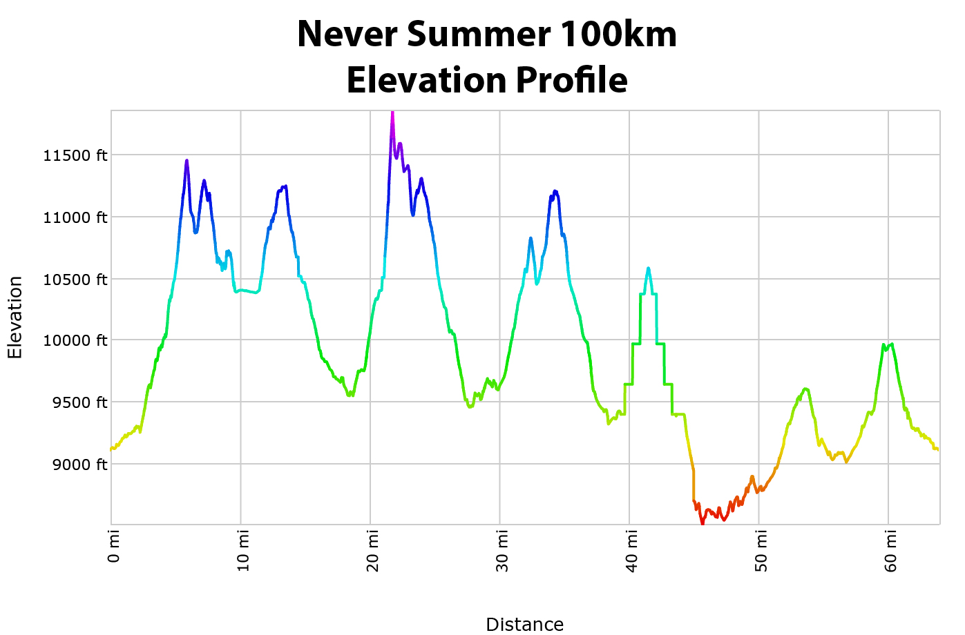
The 100km (65.3 mile) course will have approximately 14,450ft of hard-earned vertical gain and 14,450 feet of equally hard-earned vertical descent, for an elevation change total of 28,900 feet.
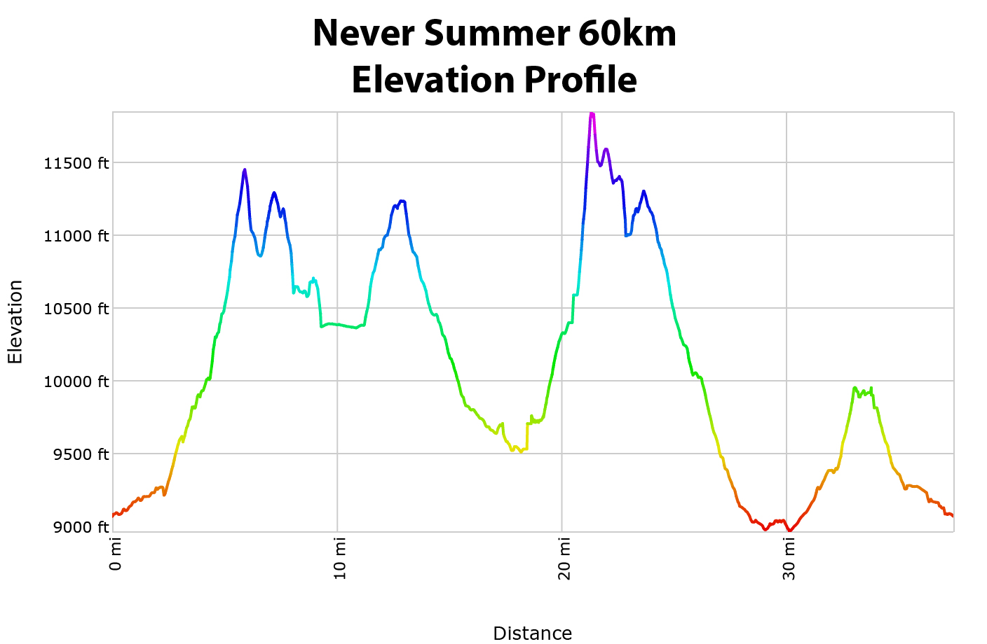
The 60km (38.5 mile) course will have approximately 8,850ft of hard-earned vertical gain and 8,850 feet of equally hard-earned vertical descent, for an elevation change total of 17,700 feet.
Course Maps
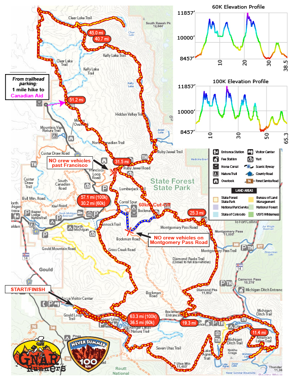
A map of the State Forest State Park trails is available here.
(Please note that much of the Never Summer course takes place on non-system trails and logging roads that do not appear on the park trail map.)
Interactive Map
Course Profile
 |
 |
Detailed Course Directions & Maps
Cell service in the area is very limited (assume non-existent). We highly recommend printing all the maps that you or your crew will need for the race before traveling to the race. The same applies for uploading GPX files.
Never Summer 100K & 60K Written Detailed Course Directions
Course GPX File
Aid Stations
| Aid Station | Mile Split | 60km Total Distance |
100km Total Distance |
Aid | Drop Bags/ Crew Access |
Vertical Gain |
Vertical Descent |
Cut-Off |
|---|---|---|---|---|---|---|---|---|
| Michigan Ditch | 11.4 | 11.4 | 11.4 | FULL | No/No | 3400 | 2100 | – |
| Diamond | 7.9 | 19.3 | 19.3 | FULL | Yes/Yes | 1100 | 2000 | 12:00p (100k) / 12:30p (60k) |
| Montgomery | 6.0 | 25.3 | 25.3 | FULL | No/No | 2900 | 1200 | – |
| Ruby Jewel | 6.2 | – | 31.5 | FULL | Yes/Hike-In | 700 | 2200 | 4:30p |
| Kelly Lake | 4.5 | – | 36.0 | Safety Only | No/No | 1900 | 800 | – |
| Clear Lake 1 | 4.7 | – | 40.7 | FULL | Yes/No | 100 | 1600 | – |
| Clear Lake 2 | 4.3 | – | 45.0 | FULL | Yes/No | 1400 | 1400 | 10:45p |
| Canadian | 6.2 | – | 51.2 | FULL | Yes/Hike-In | 600 | 1100 | 1:00a |
| Bockman (100km) | 5.9 | – | 57.1 | FULL | Yes/Yes | 1000 | 700 | 3:00a |
| Bockman (60km) | 5.0 | 30.3 | – | FULL | Yes/Yes | 50 | 2150 | 5:00p |
| Ranger Lakes | 6.2 | 36.5 | 63.3 | Limited | No/No | 1300 | 1100 | – |
| Finish | 2.0 | 38.5 | 65.3 | FULL | Yes/Yes | 50 | 250 | – |
The longest stretch without aid is from the start to Michigan Ditch Aid (11.4 miles); however, the hardest stretch for 100km runners comes between the Ruby Jewel Aid and the Clear Lake Aid. Runners should be sure to stock up at Ruby Jewel with the necessary supplies to meet their nutrition and hydration needs. This section is 9.2 miles, and occurs at high altitude, with lots of climbing on rough terrain during the heat of the day. It could take 4 hours or more to get between aid stations.
For added safety, we will have a first responder and a radio volunteer stationed at Kelly Lake, the midway point of this leg. They will have a limited supply of water treated from the lake & basic first aid, but will not have any additional aid supplies. This is intended to be used by runners who truly need it.
All full service aid stations will stock the following items:
- Gnarly Nutrition sports drink.
- Water and Ice
- Salty Snacks: Pretzels, potato chips, corn chips
- Fruit: Oranges, Bananas, Watermelon
- Sweets: Cookies, M&M’s, Gummy Bears
- Soda: Coke, Ginger Ale
- Sandwich Rolls: Flour or Corn tortillas with peanut butter & jelly or turkey & cheese.
- Potatoes in various forms (boiled, hash browns, pierogis, tots, etc)
- Later aid stations serving runners through the night will offer grilled cheese/quesadillas, soup, pierogis, hot ramen, broth, coffee/cocoa and more.
Time Cut-Offs
100km:
- Diamond (Mile 19.3) at 12:00pm. 6:30 Total time.
- Ruby Jewel (Mile 31.5) at 4:30pm. 11:00 Total time.
- Clear Lake (2nd stop Mile 45.0) at 10:45pm. 17:15 Total time.
- Canadian Yurt (Mile 51.2) at 1:00am. 19:30 Total time.
- Bockman (Mile 57.1) at 3:00am. 21:30 Total time.
60km:
- Diamond (Mile 19.3) at 12:30pm. 7:00 Total time.
- Bockman (Mile 30.3) at 5:00pm. 11:30 Total time.
Drop Bags
If you have any specific personal nutrition or gear needs, you can leave drop bags to be taken to the designated drop bag aid stations. Drop bags can be left at the start on race morning and/or during check in.
Drop bags will be allowed at:
- Diamond (60km/100km: Mile 19.3)
- Ruby Jewel (100km: Mile 31.5)
- Clear Lake (100km: Mile 40.7/45.0)
- Canadian Yurt (100km: Mile 51.2)
- Bockman (60km/100km: Mile 30.3/57.1)
- Finish
100km Drop bags from Clear Lake, Canadian, and Bockman will not be returned to the finish area until early Sunday morning and will be available at the post-race breakfast/awards. Drop bags from Diamond and Ruby Jewel will be available at the finish at the end of the day Saturday.
60km Drop bags from Bockman will not be returned to the finish area until late Friday evening. Drop bags from Diamond will be available at the finish by midday.
Course Marking
The course will be well marked with pink flagging and pink pin flags. Important intersections and turns will be marked heavily and supplemented with flour ground markings and black directional arrows on a yellow background. On longer stretches of trail without intersections, confidence flagging will be placed approximately every quarter mile. Sections of primitive trail will be marked so as to ensure flagging is in line of sight at all times.
The course will be marked in stages. Non-system trails will be marked up to a month in advance, while system trails will be marked the week of the race. Pre-runner volunteers will confirm all markings ahead of front runners on race day to ensure accuracy, but there is always a (small) chance that cattle and other wildlife in the area may damage or eat course markings. We highly recommend bringing maps and/or downloading GPX tracks to your watch just in case.
Toilets
Restrooms will be available at the start/finish, American Lakes trailhead (1.5 miles before the Diamond Aid), Ruby Jewel Aid, Canadian Aid, and Bockman Aid.
Training
There are organized training runs most weekends May-July for Never Summer, with a special Course Preview Weekend with Camping & Trail Work the in late June/early July. See the Fort Collins Trail Runners Facebook Group for details on times, locations & routes. See our Community Page for more info on both.
Crewing & Pacing
Crewing is permitted at the following aid stations:
- Diamond (19.3, 60km/100km) – 40.505442, -105.921469
- Ruby Jewel (31.5, 100km – 1.8 mile walk in) – 40.584300, -105.963285
- Canadian (51.2, 100km – 1 mile walk in) – 40.614960, -106.008194
- Bockman (30.3/57.1, 60km/100km) – 40.559134, -105.971943
Pacers may meet their 100km runner to start pacing at the Canadian or Bockman Aid Stations. One pacer is allowed per runner at a time from Canadian to the Finish; you may switch pacers at Bockman. For runners over the age of 60, pacers can begin at Ruby Jewel Aid (31.5). The last 2 miles from Ranger Lakes Aid to the finish is open for any family and friends to join their runner.
Crew & Pacing Rules
- Runners are responsible for the behavior of their crew and pacers.
- A Colorado State Parks Annual Pass or Day Pass is required to access any aid station on the course. $10 Day Passes can be obtained at the Moose Visitor Center, 0.5mi from the start/finish, or most entrance stations. The only entrance station that accepts credit cards is the main one, on CR-41 off of Highway 14 (4mi north of the start/finish). Crews planning to visit the Diamond Aid station should plan to either have their own annual pass, visit the Visitor Center or main park entrance the day before, or bring cash/check for the day-of. A park ranger may also be available during pre-race check in to sell passes and answer other questions.
- Crewing outside of designated crew aid stations is prohibited. Spectators are welcome to access additional points on the course but may only spectate and provide moral support.
- The park is open to the public so please be courteous and respectful of other park users. Bockman and Ranger Lakes Aid Stations are near major campgrounds, so please limit noise and please do not drive through the campground areas after dark.
- No parking on Highway 14.
- No crew vehicles are allowed on Ruby Jewel Rd east of the Francisco Loop.
- Crew vehicles parked along any park road must not block traffic or any trail or access road gate.
- Crews & pacers should not interfere with volunteers.
- Dogs must be on leash at all times.
- Bring your own food and supplies. Aid station and finish line food and supplies are available for runners and pacers (while on course). Please pack in your own food, water, and any other supplies that you need for the weekend. Runners may purchase extra finish and breakfast meal tickets with registration. Race weekend meal purchases will be donated to our race beneficiaries. Vegetarian, vegan, gluten free and non-alcoholic options are available as part of our standard race fare.
- No muling. Pacers may not assist their runner in any way to carry gear or provide aid outside of the designated aid stations. Pacers may crew for their runner and assist them like any other volunteer or crew inside designated aid stations.
- Carpool, carpool, carpool. Parking space is limited on the course so please make an effort to carpool whenever possible.
Crew Directions
**There is very limited cell phone and data service in the area. We highly recommend printing out hard copies of any maps and directions that you need in advance. You will not be able to rely on your phone at most locations in the park or at the start/finish.
Diamond (mile 19.3 – car accessible)
Diamond Aid is located 3/4 of a mile east of the Seven Utes Trailhead (40.502198, -105.931914), the crew-access parking area. From the Gould Community Center, head East on Highway 14 for 4 miles to the turnoff on the right for the new Seven Utes Trailhead. Crews must park here and walk the 3/4 of a mile east to the aid station location.
***No parking is allowed anywhere on Highway 14.***
Ruby Jewel (mile 31.5 – 1.8 mile hike in (400′ gain))
The Ruby Jewel Road past the Francisco Loop Road will be open only to park visitors and volunteers. Crew cars will have to park on the side of the Ruby Jewel Road anywhere before the Francisco Loop junction or further down on the side of the main park road (County Road 41) and hike, run or bike 1 to 2 miles (400′ gain) up the Ruby Jewel Road to the aid location. Ruby Jewel is a narrow, rough road so please drive carefully and watch for runners and other traffic on the road. Please follow the instructions of parking volunteers and pull over as far as you can when parking to leave the roadway clear.
From the start/finish, it’s just over 5mi west to the main park entrance. Make a right into the park and follow County Road 41 five miles to the Ruby Jewel Rd intersection. It is two miles from County Road 41 to the aid location and a mile from the Francisco Loop parking junction.
Canadian (mile 51.2 – 1 mile hike in)
Crew cars will park at the trailhead at the northern end of County Road 41, three to four miles up the road from the Ruby Jewel intersection. It is about 1 mile of gently downhill dirt road to Canadian Aid. Your runners are going to take a long time getting there from Ruby Jewel. It will take the front of the field between four and five hours, so you don’t need to be in any hurry to get out there from Ruby Jewel.
From the start/finish, it’s just over 5mi west to the main park entrance. Make a right into the park and follow County Road 41 nine miles to Horse Corral / Campsites in a loop at the end of the main park road. Park in designated sites around the loop, then hike through the gate at the Northeast corner of the loop and 1mi along the dirt road to Canadian Aid.
Bockman (mile 30.3/57.1 – car accessible)
Three-quarters of a mile from the junction of CR41 & CR41B, the Bockman Aid will be sited. 100K runners will be crossing Bockman Road there, while 60K runners will be coming the road in a westerly direction and turning into the aid. Parking will only be allowed along the south (right) side of the road and before (west of) the trail crossing and aid station. Parking will be restricted to a single side of the road. Please follow instructions of the volunteers.
From the Canadian parking lot at the end of CR41, it is 5 miles back south to the left turn onto County Road 41B (Bockman Road). The aid and crew location is 3/4 of a mile down 41B. It is also not far from the Bockman Campground, so please do not drive past the aid station location and keep noise levels down during the night.
From the start/finish, it’s just over 5mi west to the main park entrance. Make a right into the park and follow County Road 41 four miles to the Bockman Road intersection, make a right, and go 3/4mi to the aid station.
Spectating
Lake Agnes – runners pass by beautiful Lake Agnes at mile 10 on the course. This is a great spot to cheer on your runner for the first time. From the Lake Agnes trailhead it is a one mile hike uphill to the lake. To access the trailhead from the race start, drive 5 miles east on Highway 14, make a right onto the Crags/American Lakes dirt road, then make another right after a mile following signs for Lake Agnes and the Crags Campground. Stay straight at the turn for the Crags Campground and follow the rugged 2WD forest road a further mile up to the trailhead.
North Diamond Summit (11,850′) is the high point on the course at mile 22 and offers sweeping mountain views. The summit is a little over a mile with 1,500ft of climbing if accessed from Cameron Pass (where there is a good-sized parking lot). The trail from Cameron Pass is good, but not marked. To find it, follow the creek to the northwest of the parking area. The trail follows the creek to treeline after which it is a steep climb for the summit (right peak as you look at North and South Diamond). Approaching from the west side on the course route adds another couple of miles in getting to the summit and limited parking is available in the picnic area turn-out off Highway 14. This is a unique point on the course to view runners, but would preclude crewing at Diamond Aid.
Other Excursions – Go check out Jewel Lake (11,300′) another 2.5 miles and 1,600 ft up the trail from Ruby Jewel Aid. If you’re feeling perky, hoof steeply for Clark Peak (12,950′), which towers over the lake and is the high point in the Medicine Bow Mountains. The views are well worth it if you can get it done in time to meet your runner at Canadian Aid.
Race Rules
Race rules are designed to provide a safe and fair experience for everyone involved and to help ensure our ability to produce the race again next year. Major rule infractions by racers will result in immediate disqualification of the racer. Please do not argue with or harass our volunteers. Please direct any questions and feedback to us here.
- The 100km mile race will be limited to 24 hours and will end at 5:30am on Sunday morning. The 60km race will be limited to 15 hours and will end at 8:30pm on Friday evening. Please refer to the Course section of this page for intermediate cut-offs.
- At each aid station, volunteers will record runner bib numbers. Runners are responsible for making sure that aid station volunteers record their number. Please make sure that your bib number is visible from the front and call out and confirm your number when passing through an aid station. This is important so that we can keep track of runners and know that you are not lost or injured.
- If you need to drop out of the race for any reason, you must check out with the nearest aid station or course volunteer.
- Required Gear. There will be a gear check at packet pickup.
- Jacket (Wind/Waterproof Recommended)
- Warm Hat / Beanie / Buff
- Gloves
- Whistle
- Reusable Cup
- Water Capacity of at least 32oz/1L
- Recommended Gear:
(While we are not requiring this gear from the get-go, we do strongly recommend it for all participants, and reserve the right to upgrade any/all to required on short notice if the unpredictability of mountain forecasts merit doing so)
- Cell Phone
- Light + Spare Light/Batteries
- Extra Top Layer
- Pants/Tights
- Space Blanket
- Purposeful littering is prohibited and will result in an immediate disqualification.
- Stay on the trail. No bushwhacking or short cutting. In case of wet trail conditions, please run through any muddy sections to avoid widening the trail. Yield to pedestrian and horses. Mountain bikers should yield to runners, but please use common sense in all circumstances.
- Pacers are allowed from the Canadian and/or Bockman Aid Stations only. Crewing is allowed at designated aid stations only. For runners over the age of 60, pacers can begin at Ruby Jewel Aid (31.5). Please see the Crewing & Pacing section of this page for additional information & rules.
- Dogs are not allowed on the course with runners.
Schedule
Thursday 7/25:
| 3:00-7:00p: | 60km Pre-Race check in at the Gould Community Center. Thursday check in is optional, but encouraged to save time in the morning picking up your packet, dropping your drop bags, and asking any pre-race questions. |
Friday 7/26:
| 4:00a-5:15a: | 60km Pre-Race check in |
| 5:20a: | Short 60km Pre-Race briefing |
| 5:30a: | 60km Race start |
| 5:45a: | 60km Crew Briefing |
| 12:30p: | Diamond (Mile 19.3) 60km Cut-Off |
| 3:00-7:00p: | 100km Pre-Race check in at the Gould Community Center. Friday check in is optional, but encouraged to save time in the morning picking up your packet, dropping your drop bags, and asking any pre-race questions. |
| 4:00p: | 60k Awards |
| 5:00p: | Bockman (Mile 30.3) 60km Cut-Off |
| 8:30p: | 60km final race Cut-Off |
Saturday 7/27:
| 4:00a-5:15a: | 100km Pre-Race check in |
| 5:20a: | Short 100km Pre-Race briefing |
| 5:30a: | 100km race start |
| 5:45a: | 100km Crew Briefing |
| 12:00p: | Diamond (Mile 19.3) 100km Cut-Off |
| 4:30p: | Ruby Jewel (Mile 31.5) 100km Cut-Off |
| 10:45p: | Clear Lake 2 (Mile 45.0) 100km Cut-Off |
Sunday 7/28:
| 1:00a: | Canadian (Mile 51.2) 100km Cut-Off |
| 3:00a: | Bockman (Mile 57.1) 100km Cut-Off |
| 5:30a: | 100km final race Cut-Off |
| 10:00-11:30a | 100k Breakfast & Awards |
Parking & Directions
There will be parking at the Gould Community Center start/finish area for all participants, but carpooling is strongly encouraged. The Gould Community Center is located a half mile east of the State Forest State Park Moose Visitor Center on the south side of Highway 14.
Runner Drop Off: If your crew/family will be dropping you off on race morning and they do not need to park for the duration of the race, please have them drop you off at the Moose Visitor Center, a half mile to the west on Highway 14 (towards Walden and the main park entrance). There is a short connector trail to walk over, which we will mark with green glowsticks.
**No Parking Anywhere on Highway 14**
Carpooling
Your pacers & crews may check in at the start/finish to seek/offer rides. We’ll keep a list throughout the race and do our best to holler, but without cell phone service to coordinate, keep expectations mild.
Please use our Never Summer Event Facebook page to post messages to ask for a ride or offer a ride if you have space.
You may also Contact Us. If we have enough interest in carpooling from certain campgrounds, we will help facilitate a schedule and meeting locations.
Driving Directions
56750 Colorado Highway 14, Gould, Colorado 80480
The last 24-hour gas station if coming from the east is at the junction of Highways 287 and 14. Gas is available at the two stores in the small town of Rustic about halfway up the canyon, but these are only open until 7pm. You will lose cell service a mile past the Highway 287/14 junction, and may not regain it the entire weekend.
From Boulder/Denver (2:30 – 3:00 hours): The Never Summer 100k/60k stages out of Gould, Colorado, just west of Cameron Pass. Traffic coming from the Denver/Boulder area should take I-25 north to exit 269B (Highway 14/Mulberry St) and follow Highway 14 until it splits west into the Poudre Canyon, a few miles north of Fort Collins. Once in the canyon, it is an approximately 65 mile drive west to Cameron Pass on the winding road following the beautiful Wild and Scenic Poudre River. The Gould Community Center is 7.7mi after you crest the Pass, on the south side of the road.
From Steamboat (1:15 – 1:30 hours): Take Highway 40 & 14 to Walden, then continue on 14 east for another 20 miles to Gould.
From Fort Collins (1:30 – 1:45 hours): Head west on Highway 14 up the Poudre Canyon. Once in the canyon, it as an approximately 65 mile drive west to Cameron Pass on winding road following the beautiful Wild and Scenic Poudre River. The Gould Community Center is 7.7mi after you crest the Pass, on the south side of the road.
From Laramie/Cheyenne (1:30): Head south towards Jelm on WY 230 and either follow it to Walden and drive east on Highway 14 to Gould, or veer left to Jelm on WY 10/CO 103 (Laramie River Rd) to Highway 14. Head west to Cameron Pass on Highway 14; Gould will be 7.7mi from the crest of the pass.
